Tools
GLOBAL
Global Assessment Framework
Building on the scientific and technical capacities of the ISWEL consortium, an integrated global modelling assessment framework was developed to explore and answer key questions regarding global nexus challenges and potential solutions to meet the sustainable development goals (SDGs). This framework represents and connects the biophysics and economics of water, energy and land systems.
The four models that integrate the IAF are:
- the Hydrological Community Water Water Model (CWatM),
- the Hydro-economic Model (ECHO),
- the Energy-economic Model (MESSAGE) and
- the Agro-economic Model (GLOBIOM).
How these models are connected and what are the main exchanging inform flows is summarized here:
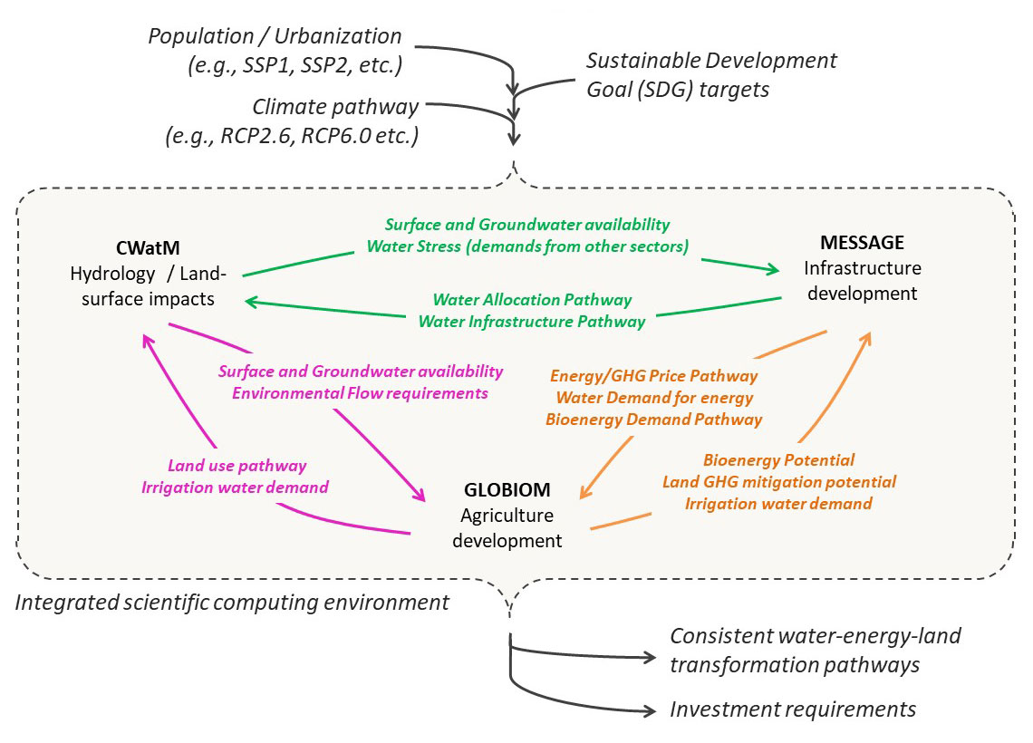
The assessment framework builds on high-resolution hydro-climate (temperature, precipitation and runoff) and socio-economic (population, GDP, income and inequality) datasets, which represent different possible developments through the 21st Century. These datasets correspond with Representative Concentrations Pathways (RCPs) and the Shared Socioeconomic Pathways (SSPs) developed by the International Panel on Climate Change (IPCC).
The SDGs and indicators represented with the global framework are summarized in the table below.
| Indicator | Targets |
| Total calorie intake |
|
| Indicator | Targets |
| Access to piped water | Universal access in urban areas to 100 liters/capita/day and 50 liters/capita/day in rural areas. |
| Wastewater collection | Half of the return flows are treated. |
| Sustainable water withdrawals |
|
| Indicator | Targets |
| Access to electricity | Universal access to electricity and 50% of the energy mix coming from renewable energies. |
| Indicator | Targets |
| Reduced animal calorie intake | Maximum of 430 kcal/capita/day for those countries exceeding the threshold. |
| Food waste | Food waste halved respect to current records. |
| Recycling of return urban flows | At least 25% of urban return flows recycled. Improved behaviour leads to 30% reduction of water demands. |
| Water intensity | Domestic, urban and agricultural water use decrease by 30% through improved behaviour. |
| Energy demands | Energy demand decreases by 40% thanks to improved consumer behaviour and efficient technologies. |
| Indicator | Targets |
| Global Greenhouse Emissions | Compliance with the Paris Agreement and limiting Global Warming to 1.5 Degrees. |
| Indicator | Targets |
| Highly biodiverse areas | At least 17% of global highly biodiverse areas being conserved. |
Global Hotspots Explorer
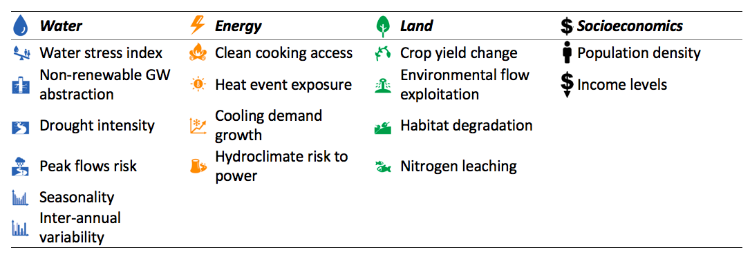
This tools allows users to explore how multi-sector risk changes with higher levels of global mean temperature rise and to what extent socioeconomic development and poverty reduction can reduce risks. Likewise, it allows the user to explore the exposure of global and vulnerable populations to overlapping multi-sectoral hotspots across scenarios.
This work is assessed across the following dimensions:
- 14 indicators (see Table 1 below), developed for this project using state-of-the-art global models, grouped within 3 sectors (water, energy and land)
- Climate change scenarios for historical (1971-2000), 1.5°, 2.0° and 3.0°C global mean temperature rise above the pre-industrial conditions, applied to the indicator datasets
- 3 socioeconomic scenarios from the Shared Socioeconomic Pathways (SSPs 1-3), with projections of population, GDP and income available to 2100 and gridded to 0.125° resolution (approx. 10km at the equator)
- Exposure of the global population, and exposure of the vulnerable population (i.e. income < $10 /day) (other income levels will be done in follow up work)
- Global coverage at 0.5° (approx. 50km at the equator) resolution over land, with regional aggregations as per the IPCC 27 SREX land region definitions.
REGIONAL
Modeling tools
Water, energy, and land optimization models are important sectoral tools that inform utility and planners towards the sustainable long-term development of natural resources. Yet, models used to develop long-term pathways consistent with the fundamental transformational changes called for under the SDGs do not represent simultaneously re-allocation of resources and capacity expansion decisions across tightly linked sectors. More integration across systems and resource planning decisions is required to capture important interactions in an explicit way, so that least-cost nexus solutions can be identified using engineering-economic tools such as optimization. Leveraging open source integrated assessment tools is also necessary to promote end-user accessibility and long term use.
To support the development of open source WEL planning tools, the project has invested significant efforts into the development of coupled and/or fully integrated WEL modeling frameworks (AMFs). These AMFs represents and connects the biophysics and economics of WEL systems, and are composed of different IIASA models, including: The hydrological model CWatM, the hydro-economic model ECHO, the energy-economic model MESSAGEix, and the land and agro-economic model GLOBIOM.
The NEST tool: Fully integrated modeling framework
NEST is an open modeling platform that integrates multi-scale energy-water-land resource optimization with distributed hydrological modeling.
The new approach provides insights into the vulnerability of water, energy and land resources to future socioeconomic and climatic change and how multi-sectoral policies, technological solutions and investments can improve the resilience and sustainability of transformation pathways while avoiding counterproductive interactions among sectors.
NEST is supported by a geospatial database and interactive, web-based results processing tools. The geospatial database houses all relevant input data used for model parameterization and calibration. NEST can be applied at different spatial and temporal resolutions, and is designed specifically to tap into the growing body of open access geospatial data available through national inventories and the earth system modeling community.
NEST links databases, processing scripts and state-of-the-art models covering multiple disciplines The core framework consists of a distributed hydrological model, CWatM, and a WEL resource supply planning model implemented in MESSAGEix, both capturing the historical period and a future time horizon.
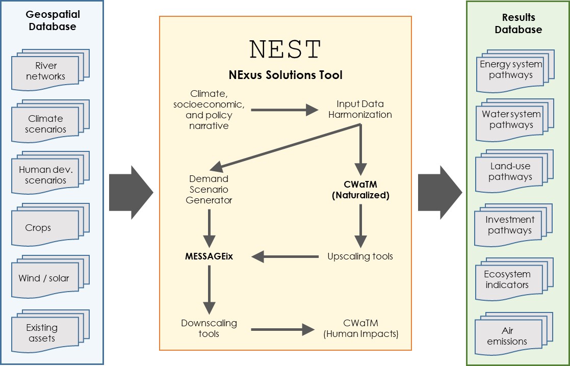
Image 1: The NEST modeling framework
Zambezi Nexus tool: Coupled modeling framework
Four models have been coupled to develop the Zambezi nexus modeling framework, namely: The hydrological model CWatM, the hydro-economic model ECHO, the land and agro-economic model GLOBIOM, and the water quality model MARINA. All models are (soft) linked; so that relevant output of one model is used as input into the other model. The exchange of information between models during the optimization and processing runs ensures that nexus challenges, trade-offs and synergies are modelled adequately. The advantage of this coupled approach is that indivual models can be plug in and out depending on the research needs. Also, this soft coupling also ensures that individual models maintain its full complexity and modeling capabilities.
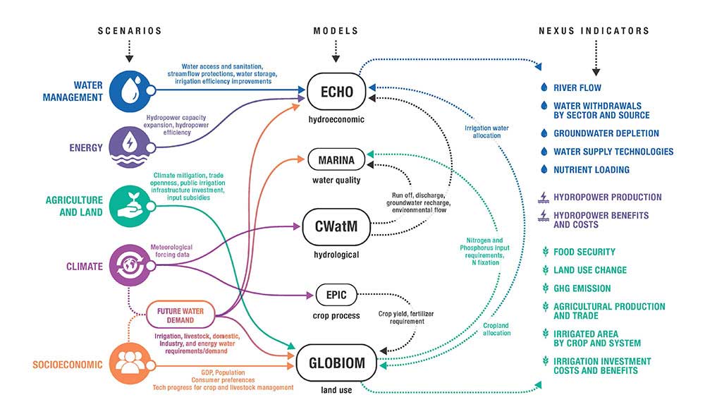
Image 2: The Zambezi Nexus modeling framework
The Zambezi Nexus tool can be applied at different spatial and temporal resolutions, and is designed specifically to tap into the growing body of open access geospatial data available through national inventories and the earth system modeling community.
Policy tools
Improving our ability to understand and manage complex, rapidly changing river basin systems is a major challenge that requires the integration of multiple sources of knowledge, tools and the cooperation with many different actors and with different backgrounds.
In addition to the basin modeling tools, the project also focused efforts in developing a number of policy tools to support the development of institutional capacities and raising awareness among non-technical audiences on the water-food-energy nexus and its management.
Nexus Game
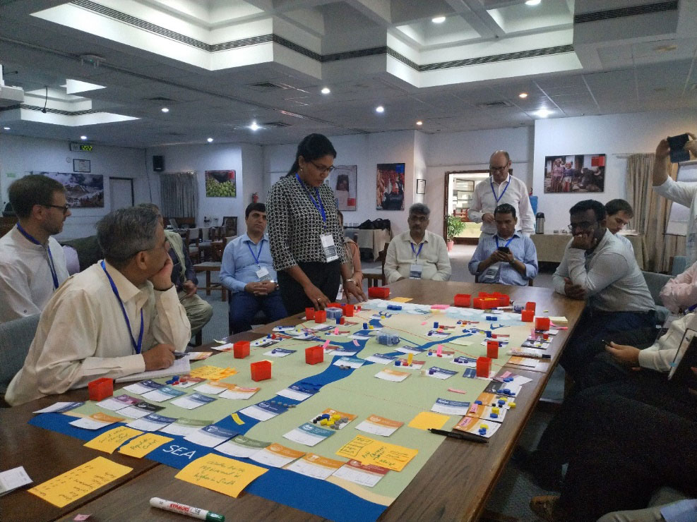
The Nexus Game gives participants a unique opportunity to get an insight into challenges of water management for energy and food production, at the same time sustaining environmental flows. The aim of the game is thus to provide an opportunity for practicing how different water management policies can lead to sustainable development of society in harmony with Nature. It can be used both as a training tool and a policy exercise. Participants strive to address water needs of population, industry, and agriculture, at the same time facing challenges of climate change. The game is designed to demonstrate many interconnected Water-Food-Energy Nexus challenges.
The Nexus Game has been developed by IIASA and the Centre for Systems Solutions (CRS) and used as part of the project to support the development of institutional capacities for WEL nexus management. Target main audience include aid workers, public administration, local communities and policy makers. Further information about the game can be found here.
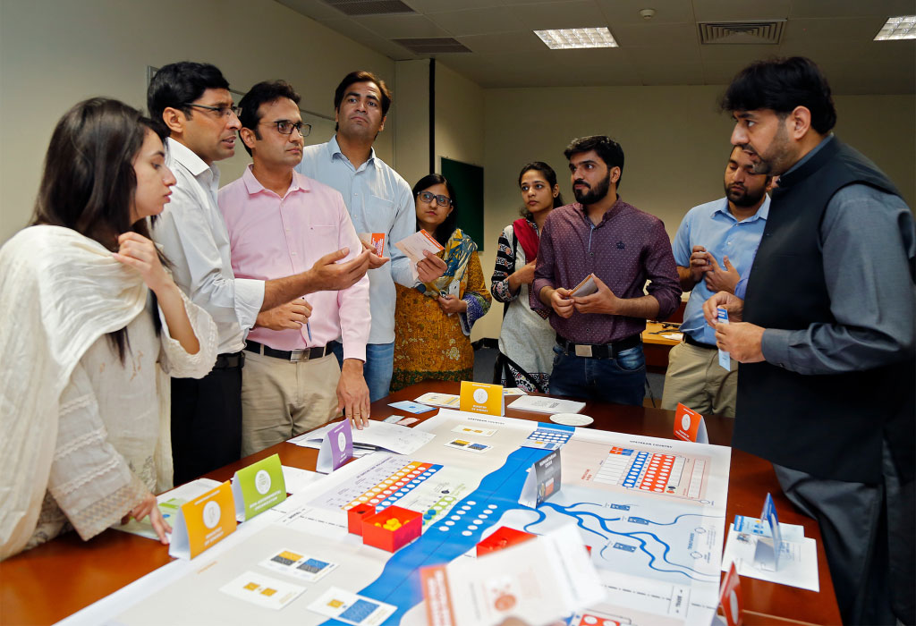
Image 3: Nexus Game Session at Lahore University of Management Sciences, March 2018
Scenario tool
The scenario tool is a participatory hands-on process to co-develop future basin visions and associated pathways with stakeholders. The premise underpinning this process is that different stakeholders have different values and priorities. Such diversity implies that different pathways are possible to achieve water-related development goals, and each one will also entail different synergies and trade-offs. Alongside with the values and priorities, it is also fundamental to acknowledge basin decisions and impacts respond to drivers at operating at different scales from local to global (e.g., climate change, political instability, population growth, migration, socio-economic development), and these shape the development of basin pathways, and need to be considered when developing robust basin scenarios. Based on this conceptual framing, the participatory scenario process identifies and evaluates with stakeholders information in the two spheres:
- aspirational targets regarding water linking to energy and land overall development goals for a basin in a given time frame (e.g. 2030, 2050) and solutions and trade‐offs associated with alternative pathways to achieving these targets, and
- an assessment of the robustness of the stakeholder pathways against different global and regional drivers (e.g. 1.5, 2 and 3-degrees climate change scenarios). To ensure that a wide range of views and priorities are explored, the approach implemented in the two basin comprised the co-development of three 4 alternative pathways: a business as usual, and three sustainability scenarios imposing some constrains.
The implementation of the participatory scenario process will be supported with the development of a scenario kit, comprising detailed maps of the basins, cards describing the main natural features, infrastructures, risks, and policy options. An important feature of this scenario tool kit is the identification of indicators to track the impacts of the different modelling scenarios. The main outputs of this activity included comprehensive narratives of at least 3 basin visions and pathways, with detailed spatial and temporal representation of challenges and possible solutions.
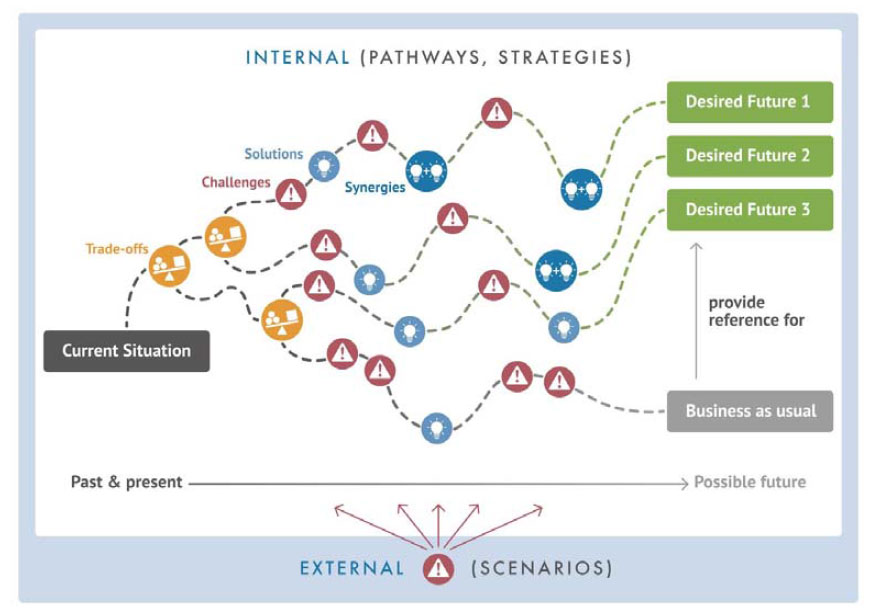
Image 4: Conceptual approach of the scenario exercise developed in ISWEL
Nexus Strategic tool
The NEXUS strategic a semi-quantitative participatory simulation tool intended to engage participants in a hands-on exercise on joint planning of nexus decisions replicating the real challenges and opportunities of a given basin.
The NEXUS strategic tool builds on the (qualitative) ISWEL scenario tool developed and on the Nexus Game. Unlike the Nexus Game, it represents the real situation of a given basin and uses real data (water, energy, and food) allowing participants to grasp the baseline water balance in the basin and based on it to develop various possible future scenarios considering competing demands between sectors and countries. Until now, it has been applied in the Indus and the Zambezi Basin.
Comparing to the qualitative scenario process it adds the key constraints so that any developed scenarios are more realistic and require intensive collaboration both between sectors and between the countries. As noted by several participants, some key basin challenges can be revealed very quickly in a transparent form e.g. certain aspects of political economy which often lead to difficult but necessary negotiations. At the same time, conflicting water demands from different sectors could also be openly negotiated while all participants could see the effects of their decisions on both the upstream and downstream part. The simulation creates also a possibility to experience future hydrological regimes that are predicted to be strongly affected by climate change increasing (and then reduced) glaciers melting.
The stakeholders appreciated how this transparent tool could support a difficult negotiation process between the stakeholders. It can act as a bridge between the modelling nexus frameworks and stakeholders’ capacity to translate its findings to their reality. Additionally, the simulation inherent transparency facilitates dialogue and realistic solution finding wherever optimal model generated solutions are not feasible for social or political reasons.
